


Street Regional Siren
UI, UX, and System Design
Project Type: Solo project. Timeline: Sep 2022 - April 2023.
Tools: Figma, Adobe Premiere Pro, Tinkercad, Ender 3 Pro Printer, Keynote, and Arduino
Skills: Background research, UI prototyping & UX design

Overview
The Street Regional Siren is a safety system that utilizes public infrastructure to detect and alert residents regarding potential dangers by analyzing recorded audio data. The accompanying mobile app also provides real time updated map and instructions for finding secure areas to guarantee the well-being of individuals.
This project not only showcases the artistry of UI, UX, and system design but also highlights the exceptional prowess in 3D model construction and prototype crafting.
.png)
Dangerous
Safe
Features

01. Danger Detection
The siren constantly gathers sound data and transfers them to a central CPU for risk analysis by comparing it with the sound data stored in the database.

02. Alert
The audio player within the siren will emits alerts to notify individuals in the surrounding area nearby.


Dangerous
Safe
03. Guidance
The siren's indicator light offers guidance towards safe areas, while additional alarm details will be displayed on the accompanying mobile application.
Problem

The escalating crime rate in public spaces has raised significant apprehension in numerous communities across California during 2020 and 2021, emphasizing the urgent need to prioritize the safety and security of citizens.
My Goal
The objective of this project is to devise a strategy aimed at safeguarding citizens and ensuring their distance from crime and other potential hazards.
Secondary Research
According to statistics, the murder/homicide crime rate experienced a 28.64% rise between 2019 and 2020, which is 24 times the 1.19% growth between 2018 and 2019. This trend poses a crucial worsening safety problem to our society.
Another newer statistic indicates that, in California, property crime exhibited an upward trend in 7 out of the top 15 counties, while violent crime showed an increasing trend in 11 out of the top 15 counties in the years 2020 and 2021.

What Already Existed
ShotSpotter is an existing safety system employs acoustic sensors to instantly detect and pinpoint gunshots. Once detected, the system swiftly analyzes the audio data to determine the exact location of the incident. This information is promptly relayed to law enforcement, enabling swift and accurate response. By offering early gunshot detection, improving law enforcement response times, and assisting in the prevention and investigation of gun-related crimes.
Upsides:
The statistics had proven that the ShotSpotter system is effective in disturbing gun violence, reducing gun crimes, and collecting evidences. One Chicago neighborhood's crime rate had reduced by 40% after the system was installed.
The ShotSpotter has the ability to distinguish impulsive and potentially hazardous sounds from other non-threatening noises. The system has an amazing 97% accuracy.
Downsides:
Every year, one city spent about a million dollars on the ShotSpotter system.
However, the ShotSpotter system still lacks the capability to offer immediate assistance to crime victims and citizens near the scenes. This limitation has raised doubts about the system's operational value between citizens.
While the mature technologies that are being used in the ShotSpotter had provided a strong foundational system for danger detection, ShotSpotter system still can not offer immediate assistance to citizens, yet it has a huge potential to turn into an immensely beneficial tool for the community.


My Hypothesis
I believe that incorporating intelligence sharing capabilities to the public into the current safety system will contribute to keeping individuals safe by helping them avoid dangerous situations.

SAFE
Ideation
My research on the ShotSpotter had led me think of iterating directional guidances onto the sensors, so the locations of the dangerous areas can be revealed to the public.
However, for the system to alert individuals, it would first require attentions. This had led me think of using the alarm tool.
Acoustic Sensor
collects sound data

Indicator Light
shows directional guide through the colors
Audio Player
plays alarm
I envisioned a smart system consisting of multiple sirens installed on street light poles, capable of automatically assessing the safety level of collected sound data by utilizing a database. These sirens would have the ability to indicate the safer or more distant direction from the sound source by emitting different colors of light.
Storyboard
.png)
System Workflow

Phase 1. Capture & Transfer

Phase 2. Assess

Phase 3. Alert & Guide
User Journey Map

Defining Dangers & Safety
I proceeded to define and set a standard for what should be considered dangerous, unsafe, and safe.
According to data from the CDC, homicide ranks as the third leading cause of death among individuals aged 1 to 44 in the United States.

And data from 2021 shows that 80% of the homicide crime are firearm homicides which can be detected by acoustic sensors.

With that being said, I decided to set the standards based on the shooting range of the most commonly used gun type in firearm homicides.

2020 Firearms Used in the Commission of Crimes
Hand guns being the most commonly used firearms has an effective range around 50 meters. This distance will become the fine line of the unsafe and safe zone in my system.
Colors

Dangerous
Unsafe
Safe
50 m
25 m
Red – Dangerous: within the range of 25 m
Yellow – Unsafe: outside of Red, within the range of 50 m
Green – Safe: outside of Yellow, within the range of 75 m
Each color corresponds to a specific safety level; these three colors will also be displayed on the indicator light of the siren. Citizens should follow the green arrow and avoid following along the red arrow in order to stay safe.
Siren Design
Although my initial idea for the siren structure was a capsule shape, I have some concerns about its limitations. While the curved surface offers visibility to viewers from the sides, it may have the drawback of potentially misleading the direction.
Capsule Shape Siren

Draft

Front
.png)
❌
✅
Side
Strength
-
There is no need for viewers to move closer to the siren in order to see the front side, as it is visible from the side.
Flaws
-
Low visibility of the front side.
-
Unclear guidance, potentially misleading.

Escalate & Redesign
Half-Cylinder Shape Siren


Lights Off
Three -Point Perspective
Front
Side


Lights On
In order to preserve the advantages of the curved surface while avoiding misleading the viewer, I ultimately opted for the half-cylinder shape.

Improvements
-
Expanding the size and general visibility.
-
The flat back offers a two-dimensional space that allows people to correlate direction.
Feedback Collection
In order to enhance my design in the current phase, I started a small exhibition to present and demonstrate my design concepts. As part of this exhibition, I prepared two informative posters and a prototype of the siren.


Explanatory Posters
I created my first prototype with an Arduino circuit, a cardboard base, and a foam shell.

Me & My Booth
First Prototype: Arduino Circuits

Although the majority of the feedback was generally positive, there were some concerns and questions raised about certain aspects of the system. And I have devised potential solutions to address these concerns.
Feedbacks

Solution: Signages

Since people do give proper attention to regulatory and service signages typically installed on light poles, thereby compliance can be ensured effectively.
Solution: Mobile Touchpoint
With a mobile touchpoint, users can access information regarding the locations of sirens and discover the quickest exit route to stay away from the dangerous areas.


Logo design

.png)
Visual design

.png)

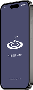
This mobile application provides users the real time updated map which is synchronized with the CPU data that all the sirens are wirelessly connected to. Triggering of the sirens will be reflected on the map immediately.
To ensure effective utilization of the system, the instruction page will be conveniently accessible at all times down the right side of the menu bar, guaranteeing its availability to all users.
Alarm Detected in Nearby Area
Another important feature of this mobile application is its ability to automatically compute the quickest exit route, assisting users to leave the alarming areas as soon as possible.
To emphasize users' freedom in choosing exit routes, I incorporated a "reroute" function into the navigation system. This feature was designed with the aim of expanding the available options for users when it comes to selecting their preferred routes. User can also choose to ignore this function.

Phase 1

Phase 2
"Waiting to confirm reroute request"

Phase 3

Phase 4
"Shrink size & standby"
4 Phases of the Reroute Button
Key Frames


Normal
Nearby Alarm Activated
Confirm Location
Confirm Info.


Yes
Navigation
Like the current route?
Arriving Destination
No


New route & Possible Reroute


Instructions & FAQ
Prototyping
As we approach to the end of the semester, I decided to move on to create a 3D printed prototype to better showcase my idea.

3D Printer

Siren Shell & Base

Upgraded Circuit

Final Prototype
End of the Year Exhibition
This is the moment where I bring all the pieces together and unveil the full picture to captivate and enlighten my audience.
This exhilarating three-hour-long show took place on the las day of my school. Despite the exhaustion, the end result undoubtedly justified my battles.


Exhibition Posters

